
1. Fires up Endomondo on Nokia C5 and start my MTB journey. Note: The data is loaded to http://www.endomondo.com live thus this cost some data charges to your mobile phone bill.
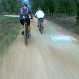
2. Starts Camera on Nokia C5 and shoot some photos.
3. Stop Endomondo once the MTB journey ends.
4. Login to Endomondo and export the tracklog to GPX. Endomondo tracks & records your training and I suppose I should be able to monitor and improve my cycling performance ;)
 |
| Screenshot of my profile on Endomondo. Click on photo for larger version. |
5. Login to Google Maps and import GPX tracklog to your maps.
View RRI_SKSB in a larger map
6. Upload photos using Picasa (Desktop version) to your Picasa Web album. Geotagging info are tagged to your uploaded photos. In Picasa Web album of those photos (click on photo below), you can see individual photo and the location of the photo taken. However tracklog on Google Maps of the above is not integrate to these photos in Picasa Web. Some manual copy & paste of coordinate of photos in Picasa Web will enable you to have those photos to be displayed on Google Maps (Click on the blue Placemark on the above Google Maps for better illustration).
 |
| RRI-SKSB Recce Ride |
PS: I was on motorcycle in this outing thus I can catch up with these avid mountainbiker.
No comments:
Post a Comment